William Bog, a Provincially Significant Wetland in Thunder Bay, ranks as the second largest wetland located entirely within an Ontario city. The bog is well known by naturalists for the presence of fourteen orchid species, other regionally rare species, and a recently described species at risk, the headwater Chilostigman caddisfly.
The bog is surpassed in area only by Mer Bleue Bog in Ottawa.
The 2006 Provinically Significant Wetland evaluation by Northern Bioscience calculated the wetland area at 723 ha. The original area was larger, over 1,000 ha before an eastern portion of the wetland (277 ha) was destroyed for the construction of the Northwood residential subdivision developed from 1965-1985. This wetland section was predominantly a patterned fen, a unique wetland type not typical south of the CN Rail line running north of Lake Nipigon.
William Bog Nature Reserve
The remaining bog is also predominately a fen. Both groundwater and surface drainage from the bog flow into the Neebing river to the south of the wetland, meandering to Lake Superior.
William Bog has long been known by local and visiting naturalists for its rich plant diversity and accessibility within the City of Thunder Bay. Botanist Claude E. Garton collected plants extensively there and many of his voucher specimens are held by numerous herbaria worldwide. In recognition of his contributions, Lakehead University named its herbarium in his honour and holds his local and regional collections.
Impacts around and within the bog are varied. Highway 11 and 17 running north-south along the now eastern side of the bog has a deep parallel ditch draining to the Neebing river. The recently developed Parkdale subdivision bordering the southern edge of the bog has a complex of ditches directed into that Ministry of Transportation’s ditch before entering the Neebing river.
The Shabaqua Extension Highway 11 and 17 bypass route cuts in the northern sector and intersects the Nipissing ridge, a glacial lake relict shoreline. This ridge is the principal water source for the wetland.
Project Area Parkdale Map
A natural gas pipeline and buried telephone line transect the eastern area of the bog. Cut lines from highway and road survey work and lot lines from older residential lot lay out during an expired City Master Plan are in the eastern section of the bog. Several old cut trails are associated with spotty timber harvest in the 1900’s or earlier.
The Good News?
The current City of Thunder Bay Official Plan designates the entire remnant eastern section of the bog as environmental protected lands.
Thunder Bay Field Naturalists club (TBFN) have a long association with the study of William Bog’s floristics and play a major stakeholder role recognized by the city in West Arthur (Parkdale) Secondary Plan Study. We have been involved in the review of development options for the land to the south and west of the remaining bog area.
Rich wetland habitat, William Bog
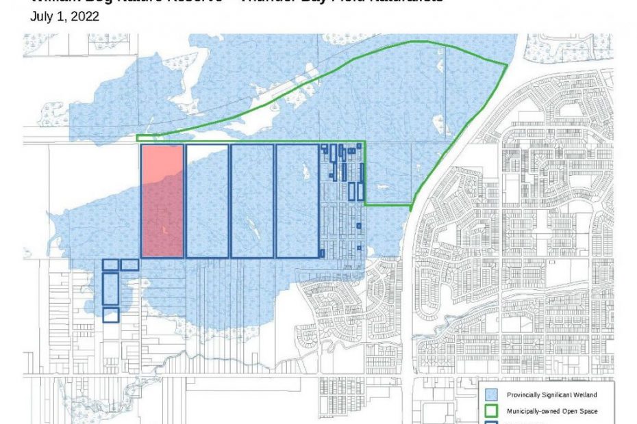
The TBFN runs a highly active and successful Nature Reserves acquisition program. In 2002, we received as a donation one of the unserved residential lots surveyed under a defunct Official Plan. That donation sparked a lot-owner ‘outreach’ program by the Nature Reserves Committee. In 2013, we received a generous donation of two 44.7 ha lots to the west of the residential lots.
In 2022, TBFN purchased the western 44.7 ha lot after 20 years of patiently repeating expressions of interest to the owner.
We continue to purchase or have accepted donations of the smaller residential lots east of the four contiguous 44.7 ha lots we own, bringing the Nature Reserve holdings to 178 ha!
Between the City designation as an environmentally protected land and TBFN’s Nature Reserve a significant portion of William Bog remaining wetland areas has now been optimistically ‘protected’ from development.
Resources
The post William Bog: Conserving a Significant Wetland Within the City of Thunder Bay appeared first on Ontario Nature.