Whether you’re a seasoned hiker, a family with young children, a birdwatcher, or someone looking for a more accessible way to experience the outdoors, Ontario Nature’s Nature Reserves offer multiple opportunities to connect with nature across the province, at your own pace.
A New Way to Navigate
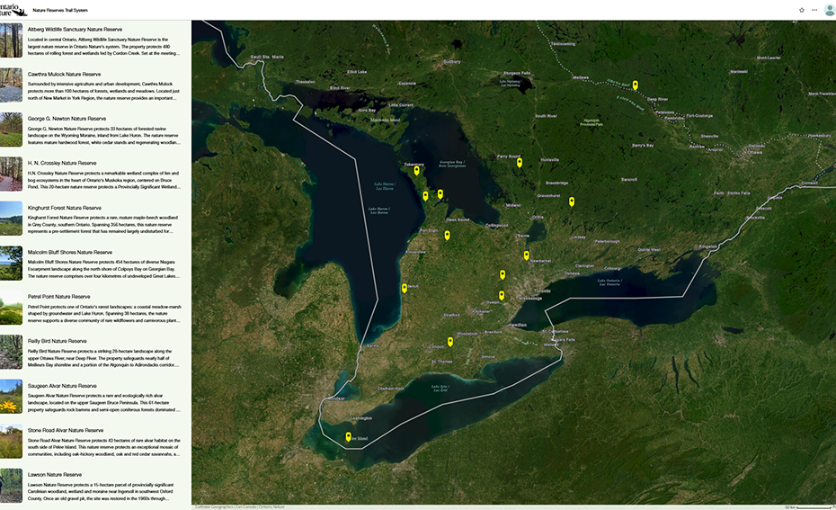
To help you enjoy these places, Ontario Nature has launched a new Nature Reserves Trail System StoryMap, featuring over 45 km of free public trails across 13 of our Nature Reserves. Bringing together maps, photos, trail information and features, this interactive resource makes it easier for you to plan your trip and find trails that meet your interests and accessibility requirements.
The Nature Reserve Trail System StoryMap is an interactive mapping tool combining maps and images to help visitors find and plan their trip to 13 of Ontario Nature’s free public nature reserves
What’s included in the StoryMap?
Parking locations and access points
Trail surfaces, distances, slope, and accessibility features
Highlights and points of interest at each Nature Reserve
Pet restrictions and other visitor guidelines
Accessible Trails at Ontario Nature’s Nature Reserves
Ontario Nature currently has accessible trails at three of our nature reserves: Petrel Point, Cawthra Mulock, and H.N. Crossley.
The interactive map lets visitors view the trails in detail, including those at Petrel Point Nature Reserve, where an accessible boardwalk winds through a coastal wetland
Located on the shores of Lake Huron, Petrel Point Nature Reserve protects 38 hectares of wetland and forest habitat, including rare Great Lakes Coastal Meadow Marsh. Here, visitors can view the numerous wildflowers — including several rare species of orchids — that bloom each spring from a network of boardwalks that wind through the nature reserve. The upgraded 0.58 km accessible boardwalk trail features a wide, wheelchair-friendly design with bumper edges, interpretive signage, and benches to rest and take in the view of the marsh.
Cawthra Mulock Nature Reserve has five trails ranging in difficulty from easy to moderate
The 107-hectare Cawthra Mulock Nature Reserve, located north of Newmarket is a haven for wildlife in a highly developed area of Central Ontario. Here, visitors can enjoy the sights and sounds of nature along the 538 m accessible trail that features a gentle grade, guiding ropes, and benches to sit and listen to the birds.
Points of interest, parking locations, and trail conditions at H.N. Crossley and 12 other nature reserves can be found in this StoryMap
Located in the heart of Muskoka, the 19-hectare H.N. Crossley Nature Reserve features an impressive “eyed” bog ecosystem. Surrounded by granite bedrock outcrops and ridges, visitors can explore the nature reserve’s diverse array of flora and fauna, including carnivorous plants, uncommon orchids, and nesting wetland. A 130 m crushed gravel accessible trail leads to an accessible look-out platform, offering a spectacular view of the bog and surrounding forest.
Every Ontario Nature Nature Reserve has a story to tell. It’s written on the limestone rock of Ontario’s southernmost island, along the rugged shores of the Saugeen Bruce Peninsula, and in the quiet forests along the Quebec-Ontario border. Experience these stories firsthand by visiting one of the trails featured in this StoryMap, or join Ontario Nature on one of their public free events, like the upcoming Hike and Social at H.N. Crossley Nature Reserve on August 6th, 2026!
By Marcus Maddalena and Sam Clapperton
Marcus Maddalena is Ontario Nature’s Nature Reserves Manager. He holds both a Bachelors and Masters of Environmental Studies from the University of Waterloo and a Diploma in Ecological Restoration and Rehabilitation. Marcus has extensive experience in the conservation and rehabilitation of rare species populations and their habitats.
Sam Clapperton was Ontario Nature’s Nature Reserves GIS Coordinator in 2026.